The following Bali Hiking trails will take you across beautiful rice fields, through villages and on the top of the holy Mount Agung. Some of the hikes are for the really fit traveler while others can be done by everyone.
The Bali hiking trails are:
1. Mount Agung
2. Mount Batur
3. Danau Bratan and nearby lakes
4. West Bali National Park
5. Tirtagangga and around
6. Candidasa and around
7. Munduk
General info on Bali hiking
The climate on Bali is dominated by rainy seasons are dry seasons. The best time to go hiking to the top of the mountains is during the dry season. During this season most trails are accessible and not slippery. Above all, it is most likely that there are no clouds or mist so the views are clear.
If you like to see sunsets on a mountain top, plan to wake up early and start walking around 4 am.
Some Bali hiking trails can be done individually but others need a guide. Some trails are just unclear on some parts of the hike. It is best to at least arrange a guide one day before the hike so proper arrangements can be made.
This can be done at the hiking location itself or at any popular tourist village. The latter will arrange everything from permits to pick up and drop off.
For most hikes, you should be properly prepared. Don’t take an example from the guides who don’t bring any food and wear flip flops all the way up.
Hiking in Bali should be done with good walking shoes, a flashlight (with extra batteries), a jumper (it can be really cold on the top), food, plenty of water and last but not least, sufficient memory/battery in your camera to make some of those stunning pictures…
Additionally, it might be useful to make a copy of your passport.
There was one time when we fully packed, ready to conquer one of the amazing mountains until we heard that we were not allowed to continue because we did not have a copy of our passport. Don’t let this happen to you.
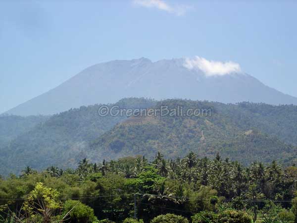
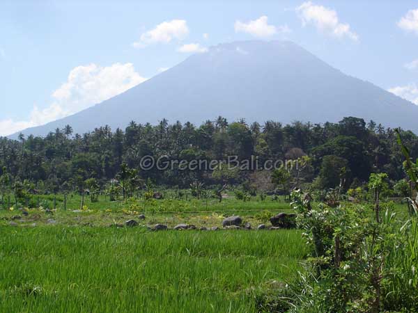
1. Mount Agung
The most sacred and highest mountain in Bali is also one of the most popular mountains to climb. This Bali hiking trail can be really tough, especially towards the summit. So you should be trained and physically fit if you have set your sight on this mountain.
The best time hiking to mount Mount Agung is from July until September. It is prohibited to go hiking during religious events though. The Balinese believe that if you ignore this rule the gods will punish you. You can believe it or not but I think out of courtesy it is better to respect this rule.
There are two trails to the top. You need a guide for both of them. In the lower part of the mountain, the area is pretty forested and the different paths make it very confusing.
If you want to be at the top to see those views Bali is famous for try to leave before 8 am. Around 12 am the clouds start to gather around the mountain. By then you won’t see anything anymore. For the sunrise trek, you will need to leave even earlier because the show starts around 6 am.
Most hikers leave at dawn the day before so they are there on time. Don’t forget to bring extra clothing if you want to do this as well, it can be freezing…
The two popular and shortest hiking trails start from Pura Besakih and along the southern slopes from Pura Pasar Agung.
The Pura Besakih route:
This trail takes you to the top of the mountain from where you can see almost every corner of Bali. It’s a difficult climb, especially near the summit when it gets really steep. The climb is about 2200m long and it takes around 6 hours to reach the summit and 5 hours to get back again.
The Pura Besakih trail is longer than the second option and you have to leave at 6 am just to be back before nightfall.
There are guides who don’t mind to take you up the mountain around midnight so you will be on the top when sunrise begins. These experienced guides can be arranged at the tourist information center near the entrance of Pura Besakih.
Pura Pasar Agung route:
This hike starts at the temple Pura Pasar Agung, located on the southern side of the mountain.
The trail takes you along the lower edge of the crater rim however you won’t be able to reach the summit of Mount Agung from here. Nonetheless, you have great views on the eastern and southern part of Bali.
All you have to do is to make an initial arrangement at Selat the day before you plan to climb the mountain from Pasar Agung temple. Here you should report at the police station so they can help you find a guide.
The hike can take up to 3 to 4 hours. The best time to start your climb from Pura Pasar Agung is early in the morning. The most common time to start hiking is really early in the morning, around 4 am.
To make sure you are already near the starting point, it is possible to spend the night near the temple. There is a small village called Sebudi, 5km from Selat that has accommodation.
Again if you prefer to have everything pre-arranged for you then you can also opt to join one of the many sunrise trekking and tours offered at most information offices in any tourist village on Bali.
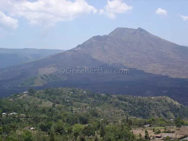
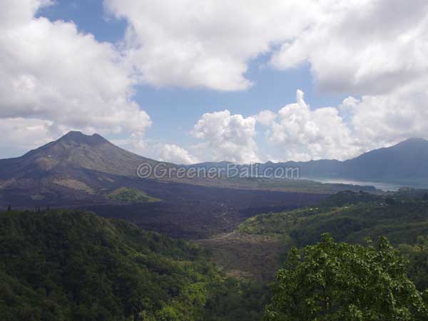
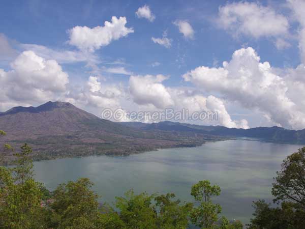
2. Mount Batur
This volcanic mountain is about 1717m high and is mostly formed by the eruption in 1917. The majority of the people visit the mountain to admire the impressive mountain itself and the gorgeous caldera of Lake Batur.
However, it is also very popular to take this Bali hiking trail really early in the morning so you can reach the summit and sunrise point of Mount Batur and gaze at the colorful spectacle.
If you are planning to go to the top of Mount Batur it is better to arrange a guide. Since the Batur sunrise trekking trail is pretty popular there are many guides to choose from. But to be on the safe side arrange an HPPGB guide at the hotels located around the lake or at the head office in Toya Bungkah.
HPPGB stands for Mount Batur Tour Guides Association and was created to prevent every person in the Batur area from calling themselves a mountain guide.
It is also helpful to have a guide to prevent other guides from following you to the top and offering their services. It is also possible to arrange hiking tours before you head to the Mount Batur area. Make sure you know exactly which hike to tour offers though.
There are different routes to choose from, from easy ones to really tough hikes. You can also take one difficult route up and the easy one down.
You should start climbing early in the morning so the clouds and mist will not spoil the view. To see the sunrise, be on the top just before 6 am.
The Easiest Trail
Let me start with the really easy hikes first, which mostly involves driving. So if you want to skip the hike and just go for the view, then this is a very relaxed option 😉
The easiest trail to the top is driving towards Songan and then turn left at Serongga. Just follow the clearly set road until you end up at a car park. From here it’s about 45 minutes walk to the top.</P
It all sounds very clear and you might think you don’t need a guide for this easy walk, but just ask an HPPGB guide to join you to avoid other guides continuously following you to the top.
Another easy route is from Kintamani. Like the previous route, you can almost reach the top by car or motorbike. Here you find another convenient parking lot and then it’s just an easy walk to the top. Your guide will be able to arrange some form of transportation if you don’t have your own.
Trails for fit hikers
For the real sturdy and fit hikers, you can leave from Pura Jati or Toya Bungkah which are both located at Lake Batur. Here you can find trails to the top. It takes around 2 to 3 hours to reach the top, so leave a 4 am to witness the sunrise. You can also start at one location and end at the other.
As a treat and to prevent stiff muscles and joints you can finalize your hike in the natural hot springs at Toya Bungkah.
You can choose the free hot springs option which is often very crowded, or head for more privacy at the Tirta Sanjiwani which is set in a nice garden and even offers spas for $25 US.
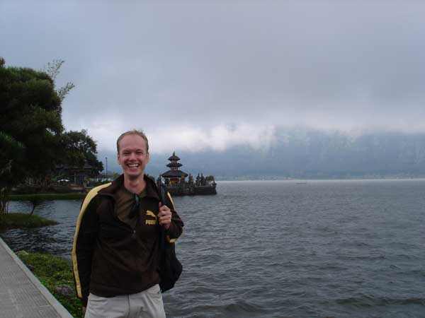
3. Danau Bratan and nearby lakes
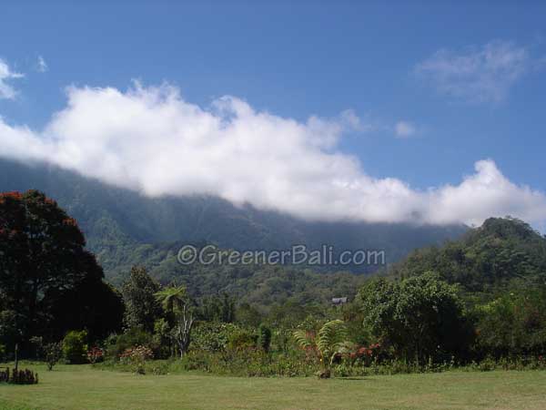
Bratan Lake is located right under the slopes of Mount Catur. During the majority of the day, it is covered by mist. It can get really chilly in this area and therefore many Balinese like to spend the weekend here to enjoy the cool climate.
The Mount Catur, which looms over the lake, creates a mystical landscape that attracts many travelers as well. They mainly come here to visit the famous Pura Ulun Danu Bratan.
However, there are many other activities here as well such as water skiing or cruising around the lake on a motorized or paddled boat.
Around the lake, you can also visit the botanical garden (Kebun Raya Eya Karya Bali) located near Candikuning. This beautiful garden has a large variety of trees and orchid species. Besides checking out the many trees and plants, it is also a nice park to enjoy a stroll without breaking a sweat for once.
However, Danau Bratan is also an ideal starting point for a popular hiking trail that takes you to the summit of Mount Catur.
Mount Catur hiking trail
To climb Mount Catur you have to start at Gua Jepang. These are 25m deep caves built by Indonesian prisoners of war during the Japanese occupation in World War II. You can get there by crossing the lake or by driving up the road that ends at the caves.
Many travelers like to reach the summit here just before sunrise. If you would want to do this as well, then you should arrange a guide a day before the climb. It is about 3 hours up and 2 hours down.
Make sure that you descend well before the afternoon before the mist sets in.
While climbing up, don’t forget to look around as well. Along the trail, there are many shrines and remains of Dutch weekend retreats.
The beginning of the hike is pretty easy to do as the trail crosses agricultural fields and ends up in a dense forest. However, once you come towards the last few kilometers it can get a bit tough.
The trail changes into a muddy and steep path where you have to do some climbing on the roots of trees. But once at the top, you’ll see Pura Puncak Mangu, an old simple-looking temple built by the first raja of Mengwi.
You are allowed to camp here if you want as long as you bring your own camping gear.
Trails nearby the lakes
Other Bali hiking trails are around Lake Buyan and Lake Tamblingan. These lakes used to be connected with each other but were separated by an earthquake in the 19th century. It is surrounded by Mount Lesong and Mount Tepak which are beautiful areas for hiking.
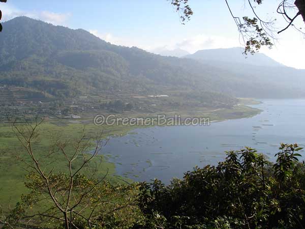
South of Danau Buyan
There is an excellent trail that starts at the southern part of Danau Buyan and ends on the southern part of Danau Tamblingan. On these trails, you can still find farmers working on their land and because tourism is not developed here, you might be the only traveler here.
About 3 kilometers from the end of this trail and towards Munduk there is a lookout point and also a nice waterfall. Around this area, you’ll find many remains of the Dutch colonial times and even some Bali Aga villages.
Hotels located near these lakes can also help you organize a 2 to 3 hours tour around the lakes, to the waterfall and Balinese villages.
4. West Bali National Park
This park is located on the outermost western side of the island. This is actually the remaining patch of forest that is considered to be of high conservation value.
One of the important species found in this park is the endemic and endangered Bali starling.
Other animals are the black macaque, wild pigs, iguana, snakes leaf monkey, muncak, barking-, sambar-, mouse-, Java, and muncak deer. Additionally, more than 200 species of plants are found here. The sound of the 300 different kinds of bird species will accompany you along your hike.
The mountainous area in the park has resulted in large differences in types of vegetation. The high amount of rainfall on the southern slopes has created lush tropical forests compared to the other side of the mountain where the savannah vegetation gives a pretty dry look.
The National Park offers several great Bali hiking opportunities. There are one or two hour walks, but if you want to hike through the entire park then you should take the 7-hour hike.
It is not allowed to enter the park without a ranger or authorized guide. All the arrangements can be made at the Park Headquarters in Cekik which is usually open from 8 am till 11 am or 2 pm from Monday till Thursday.
Expect to pay around $40 for a guided tour inclusive permits and donations. There are no accommodations within the park’s boundaries but the villages of Pulaki and Gilimanuk have places where you can spend the night. It is also possible to go camping in the park, but you should bring your own equipment with you.
Within the borders of the park, there is a marine park with amazing places to snorkel and dive.
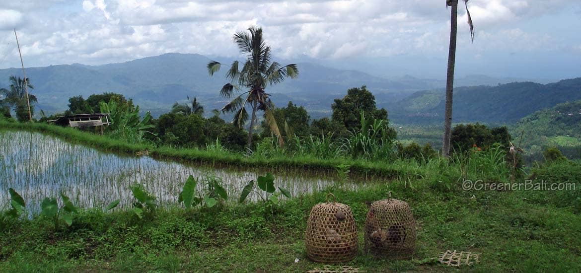
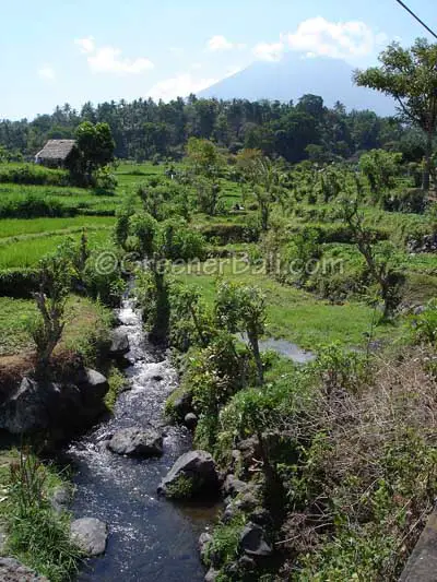
5. Tirtagangga and around
The many streams around Tirtagangga feed the complicated irrigation systems that form the amazing rice terraces found in that area. This also makes it a great area to do some hiking. The ideal time to enjoy the hike and to see the sun rays on the rice fields is in the morning. So leave around 7 am to ensure great picture opportunities.
Basically, if you want to walk around for an hour or two you can just discover the trails yourself. But if you want to go for a day hike and you want to enjoy the scenic views to the fullest then it would be wise to arrange a guide who can take you along.
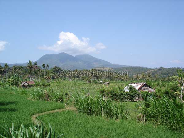
There are many hikes to choose from with all of them crossing stunning rice field terraces, traditional villages and the hills that offer magnificent views over the east Bali coastal area.
One option is the 6 hours hike starting from Tirta Gangga and back. The narrow paths will take you along rice fields and the villages of Lempuyang, Bukit Kusambi, and Budakaling.
Another option starts from Tenganan and ends at Tirtagangga. Search for the temple complex at Tenganan and from thereon head for the forests. There is a stone wall that will guide you to a school in Gumung. There are beautiful views on the rice fields from this village.
You continue your walk by passing a dam, a shrine and by crossing a shallow river. At the village, Kastala, head towards the main road and walk to the village of Bebandem. From here you can continue your hike to the village of Budakling and after hiking along the country roads you will end at Tirtagangga.
A popular Bali hiking tour is in the hills between Tirtagangga and Budakling village.
In this area, there are a lot of communities that are known for their art and crafts, such as painters, dancers, and sculptors. Budakling, on the other hand, is known for its silver- and goldsmiths.
6. Candidasa and around
The hilly landscape of Candidasa has a nice hiking trail which you can do in one day. The hike takes you up the hills where there are beautiful views on the lagoons and beach.
It would be good to arrange a guide at your hotel because it can be difficult to find the way.
But if you are feeling a bit adventurous and have a lot of time, you can go by yourself. You’ll always meet people who are very willing to help you find the right trail back again.
The starting point of this hiking trail is at the village of Tenganan. From there you can walk to Macang and Ngis to return back to Tenganan.
During the hike, you will pass through rainforests, walk along rice fields and have great views on the eastern coast of Bali, the island Nusa Penida and villages located in the middle of forests.